PHI out west

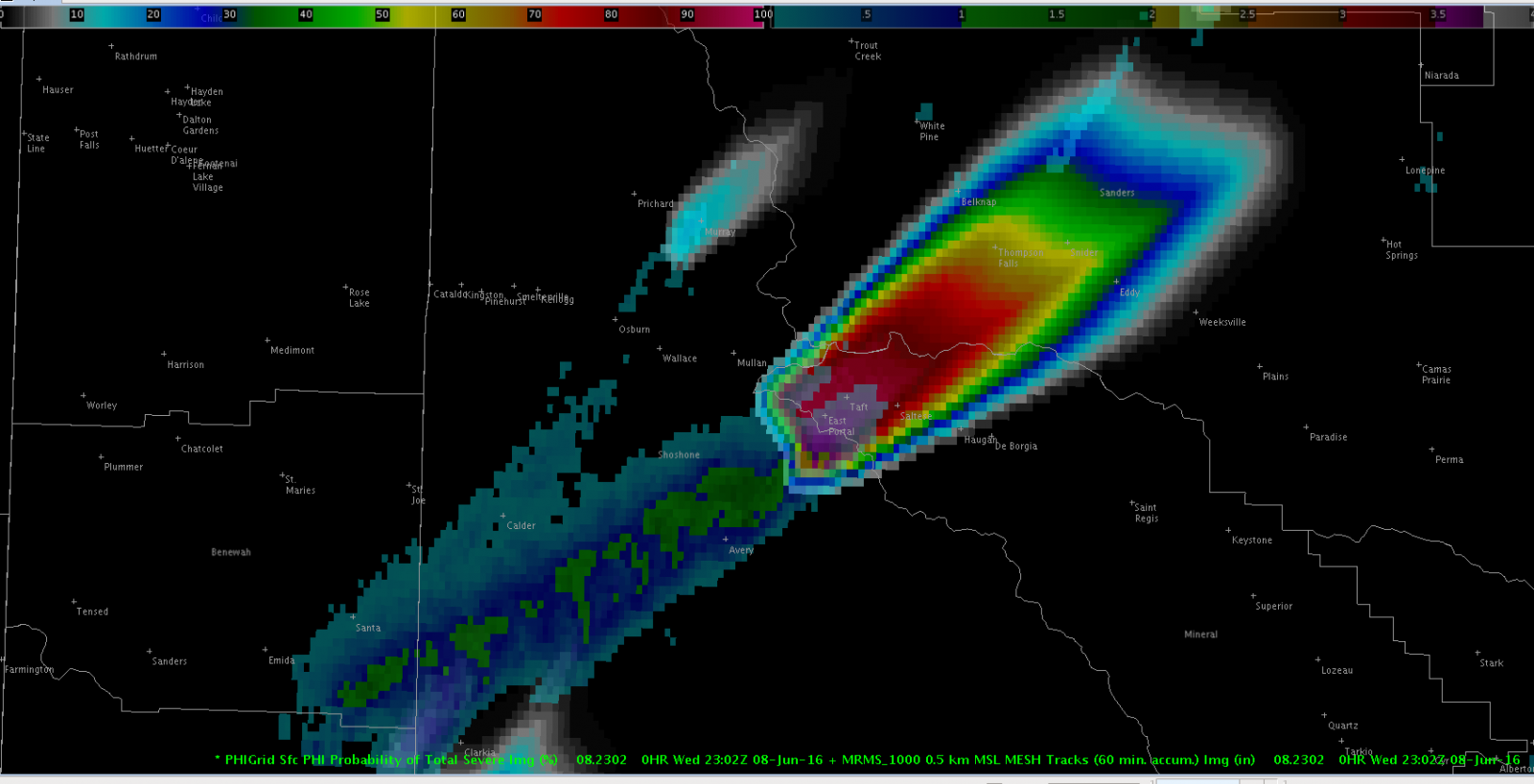
As the final week of the PHI Prototype experiment wrapped up, the weather pattern become favorable for active severe weather over the northern Rockies/Plains regions.  This enabled our project to center real time operations over parts of northern Idaho and Montana, focusing on the WFO Missoula area on Wednesday and the WFO Glasgow area on Thursday. Wednesday evening’s primary severe weather threat was large hail, and hence forecaster and the EM/media groups focused on producing and using PHI for severe storms and lightning.  Along with using product streams like MRMS, a key tool PHI HWT forecasters utilize in analysis and producing PHI is CIMSS ProbSevere.  ProbSevere provides the initial probabilistic values for severe weather and lightning for storm objects – forecasters can then adjust the algorithm values when creating their PHI plumes.

AWIPS 2 display of MRMS Maximum Estimated Hail Size swath overlaid with PHI plume forecasts of probability of severe thunderstorms.
AWIPS 2 display of MRMS Maximum Estimated Hail Size swath overlaid with PHI plume forecasts of probability of severe thunderstorms, focused on a severe storm near Taft, MT.

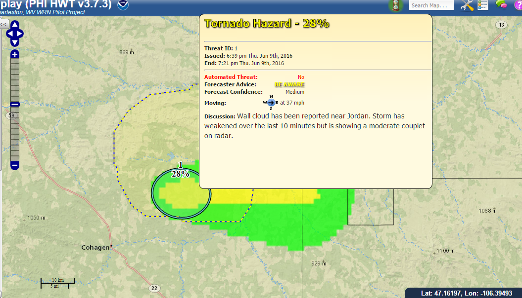
On Thursday evening, supercells moved across parts of central and eastern Montana producing damaging winds and large hail.  While conditions were not overly favorable for tornadoes, one particular supercell near Jordan, MT had a persistent wall cloud along with some reports of funnel clouds.  Along with monitoring the typical severe weather data, HWT forecasters also were able to see realtime video and pictures from storm chasers in the region.  This data was utilized to produce PHI for tornado potential, with most of the PHI objects giving information about lower probabilities than might typically be associated with tornado warning situations.  The forecaster and EM/media groups then discussed how this probabilistic information might be utilized to help improve decision making and provision of severe weather information for the public.

PHI plume for tornado probability for a supercell storm near Jordan, MT. The text in the pop-up window is a potential text product based on NWS Hazard Simplification project prototypes. The yellow outlined box is the representation of a legacy severe thunderstorm warning derived from severe thunderstorm PHI data.
PHI plume for tornado probability for a supercell storm southeast of Jordan, MT. The text in the pop-up window is a potential text product based on NWS Hazard Simplification project prototypes. The yellow outlined box is the representation of a legacy severe thunderstorm warning derived from severe thunderstorm PHI data.


Tags: None

PHI in the tropics

On the first day of the third and final week of the PHI Prototype Experiment, Tropical Storm Colin was impacting Florida during the afternoon hours when the initial shakeout operational session was underway.  Hence, this region was selected as the operations area for the realtime period of operations.  Forecasters generated probabilistic hazard guidance for potential tornadoes, damaging winds and lightning with squalls and convective cells moving across Florida in association with Colin.  This included experimenting with producing lower probability tornado forecasts for small supercells which are common with landfalling tropical systems.

PHI plume and associated NWS HazSimp based text for a squall with rotation near Port Charlotte, FL.
PHI plume and associated NWS HazSimp based text for a squall with rotation east of Port Charlotte, FL.

Emergency managers and broadcasters evaluated using the PHI to make decisions about realistic scenarios such as closing schools, cancelling events, etc..  During the end of day debrief, these users discussed potential pros and cons of the PHI paradigm for tropical cyclone situations along with the researchers and NWS forecasters.

End of day debrief after HWT operations for Tropical Storm Colin.


Tags: None

International Participation in HWT

Not only do NWS forecasters and partners from around the United States participate in HWT experiments each spring, but meteorologists from around the globe also travel to Norman to be a part of efforts such as FACETs.  These meteorologists are able to learn about the research going on at NSSL and OU and take that back to their own meteorological services, and also contribute their perspective and expertise based on the natural hazard services and warning systems in their own countries.

During the week of May 13th, two meteorologists from Environment and Climate Change Canada observed and participated in the PHI-Hazards Services Experiment.  These meteorologists work as forecasters at the Meteorological Services Canada Prairie/Arctic Storm Prediction Centre in Winnipeg.  Along with observing the PHI-HS experiment, they also participated in the Storm Prediction Center’s Spring Forecasting Experiment, which includes among its research goals this year projects to examine methodologies to produce higher temporal resolution probabilistic outlooks for severe storms.  The week of May 20th saw Mark Bevan of the UK Met Office participate in the PHI Prototype Experiment.  Mark works as a Met Office Civil Contingencies Advisor, working to provide weather services and decision support to government officials in southwest England.  Mark provided the experiment team with valuable perspective on the warning and hazardous weather support system in the UK, and also gained knowledge about FACETs which hopes to prove useful in developing and improving warning systems for short term weather hazards in the UK.

Mark Bevan from the UK Meteorological Office (foreground) participates with NWS forecasters, broadcasters, emergency managers and researchers in an event debrief during week 2 of the PHI prototype experiment.
Mark Bevan from the UK Met Office (foreground) participates with NWS forecasters, broadcasters, emergency managers and researchers in an end of week debrief at the end of week 2 of the PHI prototype experiment.
Tags: None