Author: Zac Flamig
Zac Flamig and JJ Gourley’s proposal to develop an app for identifying flash flood “hotspots” awarded at AGU annual meeting
Optimizing Local Thresholds for Flash Flood Prediction
A student led project, Zachary Flamig and his advisor Jonathan Gourley, submitted FLASH (Flooded Locations And Simulated Hydrographs) – a project that leverages existing technologies, resources, infrastructure and relationships to address critical data, knowledge and assessment gaps that will enhance the effectiveness of flood response and mitigation strategies
The Thriving Earth Exchange (TEX) and Amazon Web Services (AWS) are collaborating to use cloud-computing and Earth and space science to advance solutions to community challenges related to natural resources, climate change and natural hazards.
Winners Receive:
- $15,000 in grant funds to use AWS on-demand cloud services.
- Free registration to attend the annual 2015 AGU Fall Meeting, an Earth and space science conference attracting over 24,000 attendees. Assistance and direction in highlighting the project to enable adaptation by other communities and increase broader impact.
GIS Day Poster Contest Award
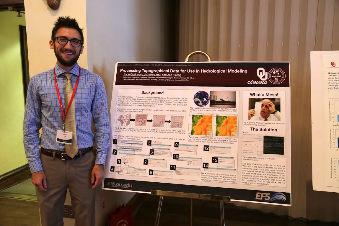
Graduate student and PhD candidate Race Clark (OU/CIMMS) won 3rd place at the 2015 OU GIS Day poster contest held November 17, 2015 in Norman, OK. His poster was titled “Processing Topographical Data for Hydrological Modeling”, which presented a new software tool for speeding up topographical preprocessing for hydrological models. This software tool is primarily designed for use during international capacity building workshops. His coauthor on the poster is fellow graduate student and PhD candidate Zac Flamig (OU/CIMMS). Both students are advised by Drs. J.J. Gourley (NOAA/NSSL) and Yang Hong (OU Civil and Environmental Engineering).
National Weather Association Poster Contest Winners

Continuing a strong 2015 conference showing by students in the FLASH group, Race Clark and Galateia Terti won 1st and 2nd place respectively in the graduate student poster contest at the 40th Annual Meeting of the National Weather Association. The annual meeting was held October 17th-22nd in Oklahoma City, Oklahoma. Race’s poster was titled “Towards Hazard Services Recommenders for Flash Flood Forecasting” while Galateia presented “Target the warnings: Probabilistic flash flood casualties prediction.”
Manab Wins SEJ Poster Contest Award
Manabendra Saharia, Ph.D. student in CEES/ARRC, won 1st place in the graduate student poster contest at the Society of Environmental Journalism (SEJ) 25th Annual Conference. The conference was held in Norman, Oklahoma from October 7th-11th, 2015. Manab’s poster focused on his work to identify the basins in the US with the fastest rainfall-runoff response.
FLASH Case Study on the Blanco River
On the evening of May 23rd into the early morning of May 24th, 2015 the Blanco River in Texas experienced a significant flooding event resulting in the closure of I-35 north & southbound near the city of San Marcos, TX. There were also multiple high-water rescues in the area including helicopter rescues of victims trapped in houses. The Hays County jail in Texas was also evacuated due to threatening flood waters. The FLASH development system was running for this event producing products forecasting & monitoring the flooding in near real time.
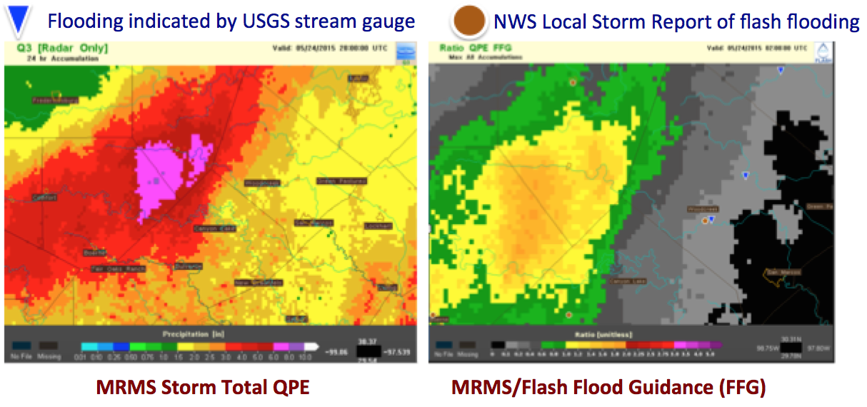
Traditional rainfall based products including the rainfall accumulation and the ratio of rainfall to flash flood guidance highlight a large area northwest of San Marcos for flooding impacts. The storm system produced 6-8″ of rain over the region to the northwest resulting in exceedance of flash flood guidance by 160-180%.
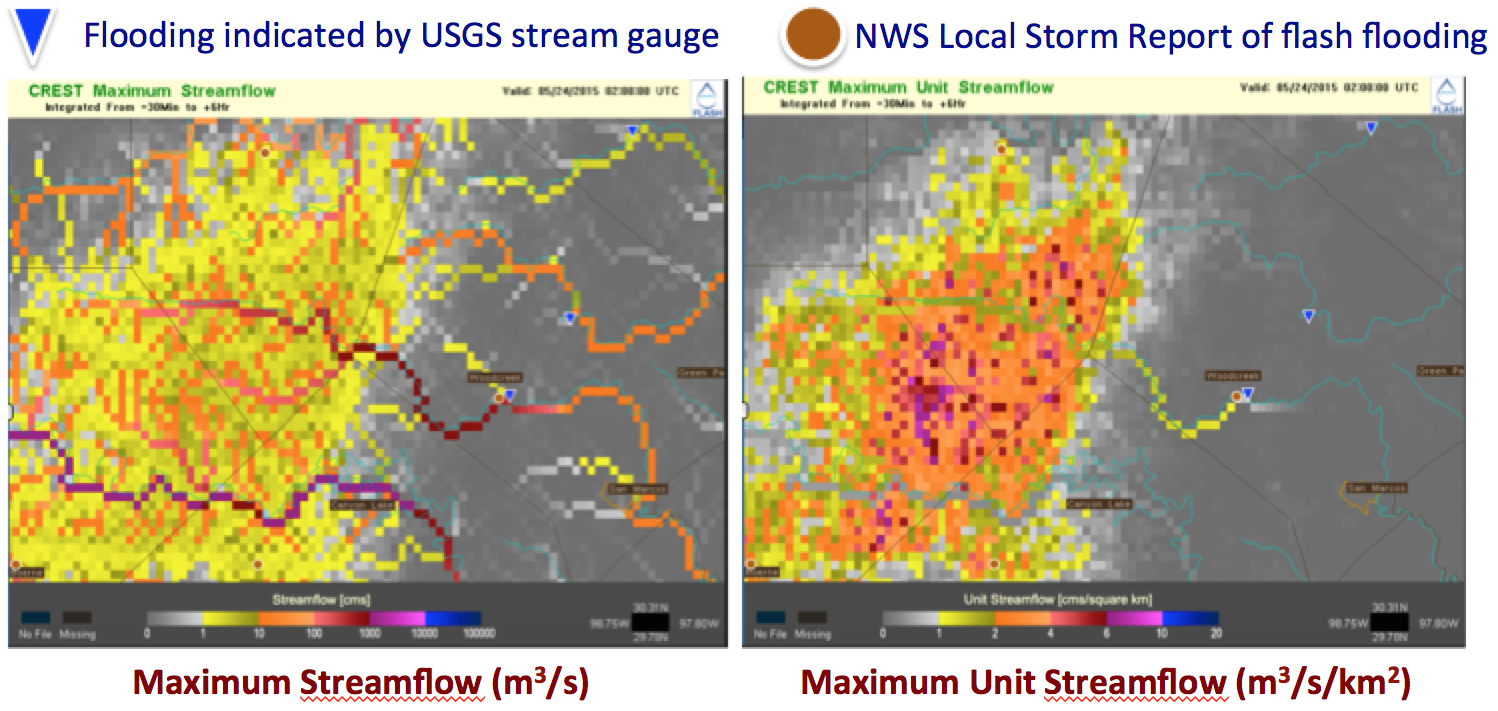
The FLASH hydrologic model based products correctly show the heavy rainfall being concentrated into the rivers and the downstream flooding impacts in San Marcos resulting from the heavy rainfall to the northwest of the region.

Conclusions
- This was a very heavy rainfall event that was captured well by MRMS radar-only estimates
- The flash flood guidance product indicated significant exceedance over threshold values, but the areas of concern were limited to the headwaters of the Blancos river
- The distributed hydrologic model forecasts better refined the threat area to the Blancos river and provided several hours of lead time
- This event clearly highlights the need to account for overland flow and routing, displacing the impacts well downstream of the causative rainfall
FLASH Performance with Recent Flood Events in Oklahoma & Texas
The MRMS-FLASH system, running in a real-time demonstration mode for several years now, performed admirably for the recent flash flooding events in Oklahoma and Texas. The MRMS-FLASH system runs in a completely automated fashion ingesting quantitative precipitation estimates every 5-minutes from the MRMS mosaic of NEXRAD data. The FLASH hydrologic modeling system subsequently produces 6-hour forecast hydrographs for everywhere across the CONUS.
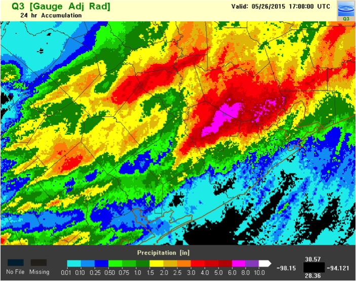
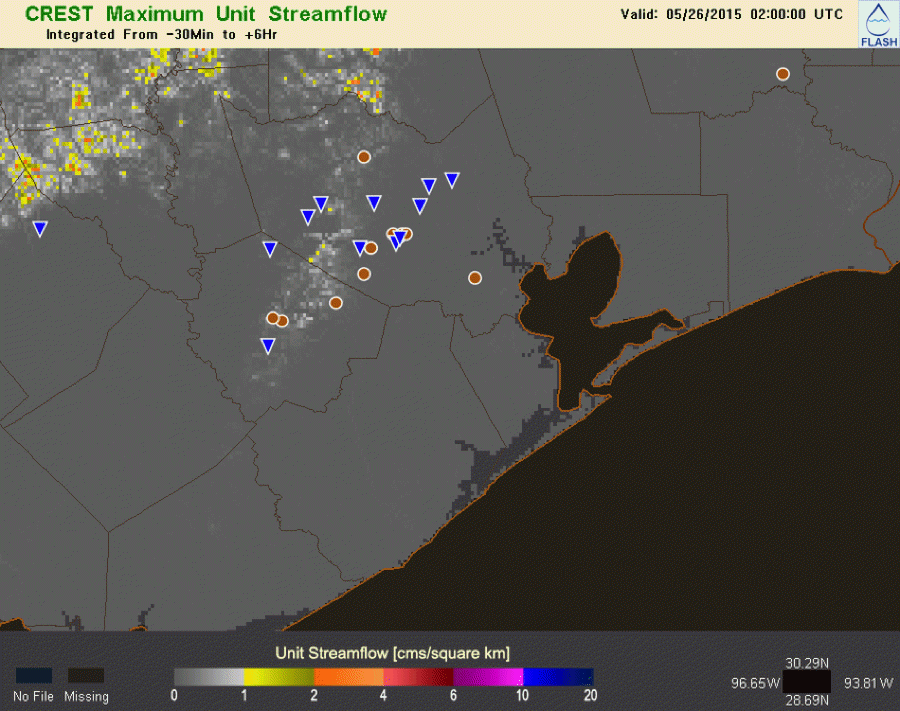
On evening of May 25th, 2015 the city of Houston, Texas experienced a serious flash flooding event. MRMS precipitation estimates indicate that the western portions of the city experienced 6-8″ of rainfall.
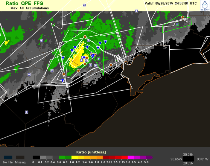
The ratio of precipitation to flash flood guidance shows exceedance values of 100-140% over this area, however some of the USGS stream gauges reporting flash flooding (blue triangles) and the flash flood local storm reports (brown circles) fall outside of this region. This product is important because it is equivalent to the main tool operational NWS forecasters have available for flash flood monitoring and prediction.
The Coupled Routing and Excess Storage (CREST) distributed hydrologic model, a part of the MRMS-FLASH hydrologic modeling suite, generates maps of streamflow and unit streamflow (cubic meters per second per square kilometer) every 15 minutes. Comparisons between the observations of flash flooding and the maps of unit streamflow show a good correspondence between areas of high unit streamflows and flash flooding.
The MRMS-FLASH suite of hydrologic models are able to correctly identify areas of flash flooding thanks to the incorporation of
- Stream & overland routing
- Modeling of impervious surfaces
New Book – Radar Hydrology: Principles, Models, and Applications
 Published: December 23, 2014 by CRC Press
Radar Hydrology: Principles, Models, and Applications provides graduate students, operational forecasters, and researchers with a theoretical framework and practical knowledge of radar precipitation estimation. The only text on the market solely devoted to radar hydrology, this comprehensive reference:
- Begins with a brief introduction to radar
- Focuses on the processing of radar data to arrive at accurate estimates of rainfall
- Addresses advanced radar sensing principles and applications
- Covers radar technologies for observing each component of the hydrologic cycle
- Examines state-of-the-art hydrologic models and their inputs, parameters, state variables, calibration procedures, and outputs
- Discusses contemporary approaches in data assimilation
- Concludes with methods, case studies, and prediction system design
- Includes downloadable MATLAB® content
Flooding is the #1 weather-related natural disaster worldwide. Radar Hydrology: Principles, Models, and Applications aids in understanding the physical systems and detection tools, as well as designing prediction systems.
Editorial Reviews
“This is the first book on radar hydrology written by hydrologists. Whereas the excellent knowledge of radar technology by the authors permits an adequate coverage of the principles of rainfall rate estimation by radar, their hydrological background allows them to provide a unique message on the benefits (and on the remaining challenges) in exploiting radar techniques in hydrology. … In a clear and concise manner, the book combines topics from different scientific disciplines into a unified approach aiming to guide the reader through the requirements, strengths, and pitfalls of the application of radar technology in hydrology—mostly for flood prediction. Chapters include excellent discussion of theory, data analysis, and applications, along with several cross references for further review and useful conclusions.”
2014 HWT-Hydro Final Report
The final report on the inaugural Hazardous Weather Testbed Hydro experiment has been released. The report details how the experiment was run, configuration details for AWIPS2, conclusions from the experiment and recommendations for future iterations of the experiment. Thanks again to all of our participants!
FLASH team participates in the Integrated Precipitation and Hydrology Experiment (IPHEx)
Website hosting MRMS, FLASH, and NOXP products: http://wdssii.nssl.noaa.gov/web/wdss2/products/radar/iphex.shtml
More information about IPHEX can be found here: http://iphex.pratt.duke.edu
And here: http://pmm.nasa.gov/IPHEx