Not a whole lot going on this evening. However, 3D VAR (see image below) still depicting weak signals of updraft (upper left) and vorticity (lower left) with a garden variety t-storm west of Longfellow, TX (reflectivity in the upper right).

AMS

Not a whole lot going on this evening. However, 3D VAR (see image below) still depicting weak signals of updraft (upper left) and vorticity (lower left) with a garden variety t-storm west of Longfellow, TX (reflectivity in the upper right).
AMS
Because storms near EPZ have gone below severe limits, we’ve moved our EPZ folks to WFO MAF to work some storms in the Big Bend area.
Because the BRO storms have moved offshore, or are staying in Mexico, we’ve moved our BRO folks to Florida. One is working JAX (recent “real” warning issued there), and one working MLB (PGLM data possibilities).
Otherwise, things are getting rather quiet across the nation, and we still have until 9pm! We’ll be done at 815 however to start feedback surveys.
Greg Stumpf, EWP2012 Week #1 Coordinator
thunderstorm activity has diminished across the forecast area and the environment favored multicell organization. main impact will be heavy rain with isolated storms creating 1/2 inch at most based on latest hail algorithm trends. HRRR composite reflectivity supports this trend during the next 1-2 hours while the effects of daytime heating remain.
3DVAR maximum updraft intensity (2-hour) versus MR/MS Max Expected Size of Hail (2-hour) for the tornado-warned storm in the Brownsville CWA. Max MESH frequently follows the peak updraft intensity in storms that produce large hail.

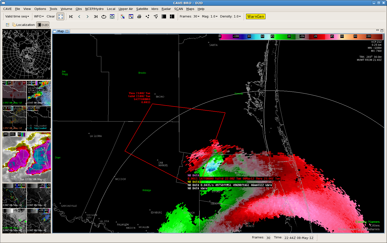
Severe/possibly tornadic thunderstorm…currently located over northern Mexico west of BRO…has been showing an increasing trend. Updraft helicity have have increased to 87 m/s2 with surface vorticity values to 16 s-1. It appears a rear flank downdraft has now developed on the south side of the storm. Hovis/Barnes

Our visiting forecasters and EWP support team hard at work issuing warnings for EPZ and BRO.

Greg Stumpf, EWP2012 Week #1 Coordinator
Possible Tornadic thunderstorm continues to push east across northeast Hidalgo county. Maximum Surface vorticity values have increase to 22 s-1 and updraft helicity values have increase to 447 m/s2. Have not received any reports from this storm. However…it has been moving across an area where not many people live. Hovis/Barnes
Impressive storm continues to move east across portions of south Texas. Max Vorticity values have increased to 21.5 s-1…with updraft helicity values to 539 m/s2. Maximum updraft values are much lower than expected with 19 m/s. However…feel these numbers are low because radars are all examining the storm around 7500 ft AGL. Hovi s/Barnes
The synthetic WRF run at 05082012 at 0Z correctly predicted several upper level features and mesoscales features correctly for the afternoon of 05082012. The following 4 images show synthetic WRF images of IR (upper left), WV (upper right), and 10.35u-12.3u IR Band Difference (lower left). Looking at the WV imagery you can see an upper low over the U.S. Southwest as well as an upper trough over the upper Midwest. In the IR and WV imagery you can see convection occurring from AZ to NM to TX to CO to Old Mexico. In the brighter white areas of IR, you can see low level cloud cover. In the Band Difference image, you can see the area of best moisture and “hot spot” for convective initiation in the southern tip of TX and into Mexico. The 5th image below is the true observed IR (upper left) and WV (upper right) which verifies the synthetic WRF.
This imagery would be very helpful to forecasters in the field because it seems to do a decent job of predicting upper level features, low level clouds, and convection 12-20 hrs in advance.
17Z Synthetic:

18Z Synthetic:

19Z Synthetic:

20Z Synthetic:

20Z Observed IR and WV:

AMS
