PHI and Pulse Storms

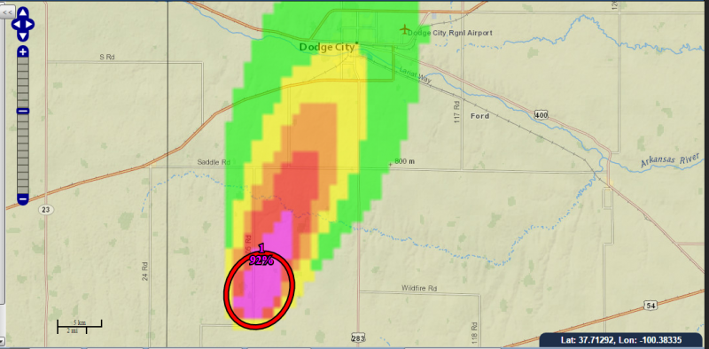
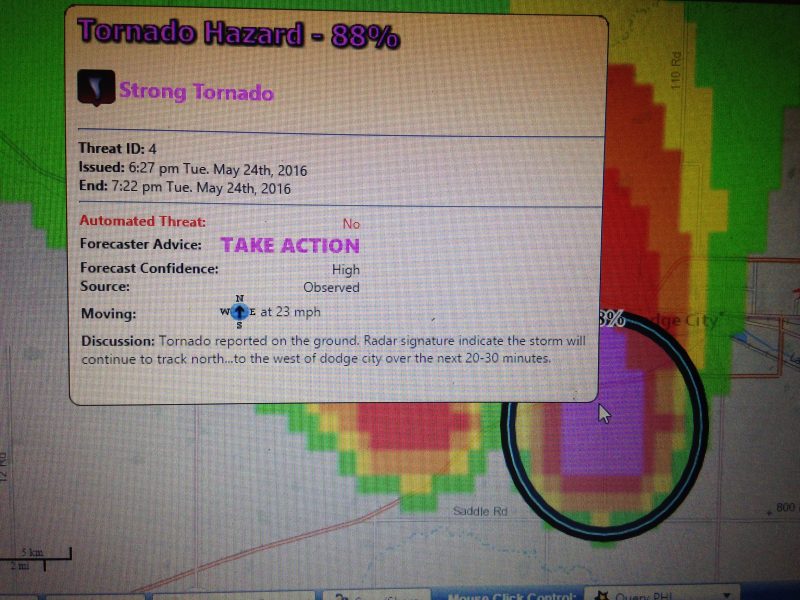
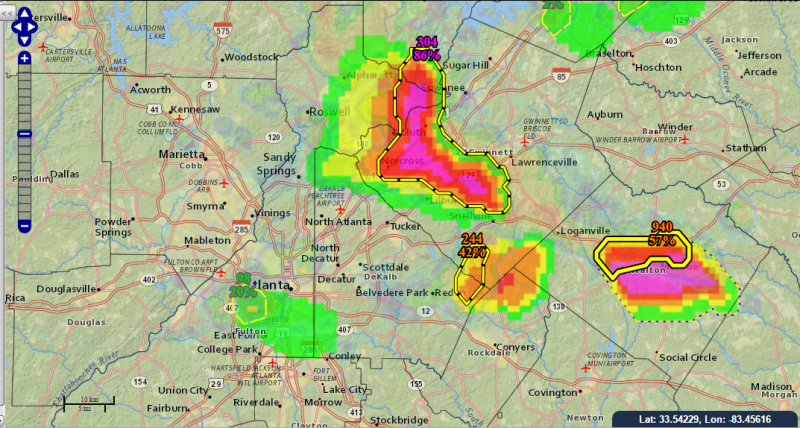
For the concept of probabilistic hazard information to be a viable paradigm for providing severe thunderstorm hazard information, it must be able to be robustly produced and utilized for all different modes of storms.  In this year’s PHI Prototype experiment, one of the historical cases being “worked” by the participants is a summer pulse severe storm episode from Georgia.  Below is an example of radar and corresponding PHI guidance produced by a blend of forecaster and algorithm output toward the end of the event.

End of sim close up ATL PHI close_up_ATL_radar and PHI

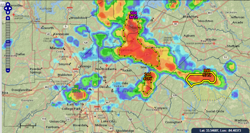
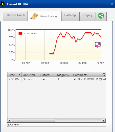
In addition to the forecasters evaluating the benefits and challenges of the PHI system for these type of pulse events, EMs and broadcasters utilized the NWS EDD to display the data and make decisions about summer type related situations.  For example, EMs utilized lightning and hail/wind PHI to make decisions about potentially evacuating large outdoor venues and adjusting airport operations.  One tool that can be used on the EDD is the ability for the user to display a time series of the PHI probability values for a given storm, along with any reports of severe weather received.

EDD display of time series of probability of severe weather from the ProvSevere algorithm with corresponding reports of severe weather.
EDD display of time series of the PHI probability of severe weather with corresponding reports of severe weather.
Tags: None

PHI Prototype Week 2 off to Busy Start

The second week of the PHI prototype experiment kicked off on Monday, and swung into full gear on Tuesday with an active period of realtime weather.  Evening operations focused on the tornadic supercells affecting the NWS Dodge City service area, and in particular the storm that produced multiple tornadoes in the immediate Dodge City vicinity.

HWT probabilistic hazard plume for tornado to the southwest of Dodge City around 6 pm 24 May.

Emergency managers and our broadcaster were “positioned” in the Dodge City area to perform job related tasks, and evaluate how PHI and associated text products based on the NWS Hazard Simplification project assisted in their decision making.  The mock operations were quite realistic, with emergency managers making decisions about deploying search and rescue teams while additional storms were threatening, and our broadcast team conducting interviews with HWT forecasters about the storms.  HWT forecasters monitored the live feed from our broadcaster, and also live chase footage via the Internet.

IMG_0936
NWS EDD display of text popup window associated with PHI object for tornado just southwest of Dodge City around 6:30 pm.


Tags: None

PHI-HS and Collaboration

IMG_0927
NWS forecaster utilizing AWIPS Hazard Services to generate experimental PHI information for a realtime severe convective event over Florida. Video recorders record operations so that researchers can go back and analyze the forecaster’s actions during the experiment.

This week is the second week of the PHI-HS experiment in the Hazardous Weather Testbed, in which two NWS forecasters are testing and evaluating the production of probabilistic hazard information (PHI) using AWIPS Hazard Services.  One of the important aspects being tested as part of this experiment is how to collaborate the production of PHI across more than one NWS County Warning Area (CWA).  During two of the real time and archived weather events the two NWS forecasters work during the week, each forecaster was assigned a specific area of responsibility.  As storms moved from one area of responsibility to another, the forecasters used NWSChat and Hazard Services to collaborate in an effort to produce consistent, accurate PHI for these storms.   Researchers from NOAA NSSL and GSD, NWS Warning Decision Training Dvision, University of Oklahoma CIMMS, and the University of Akron will evaluate results from the experiment to examine the various technical and procedural issues surrounding effective collaboration.  This testing will not only help examine coordination issues related to PHI production, but could also help provide insight into warning and forecast collaboration issues more generally.

Tags: None

Testing PHI and new messaging

The below picture shows an example of some of the products that emergency managers and broadcasters are evaluating this week for severe weather related decision making.  Each day, NWS forecasters produce these products during two 60 to 90 minute periods – one based on an archived displaced real-time case, and the other a live weather scenario.   Over the last two days, both of the live weather scenarios were in the lower Ohio Valley region.

IMG_0850
Example of tornado PHI “object” with corresponding probabilistic hazard plume, with a corresponding prototype HazSimp based message.

While NWS forecasters are producing forecast information in the HWT, the EMs and broadcasters are in two separate rooms, analyzing and utilizing the forecast information in job related tasks.  Using the NWS Experimental Data Display (EDD), developed by WFO Charleston, WV, the EMs and broadcasters can view not only the probabilistic hazard information in various graphical formats, but also prototype text-based messaging based on the NWS Hazard Simplification project.  Social and physical science researchers are also in each of the three rooms, working on research goals that will help explore a number of the social and physical science issues related to FACETs.

Tags: None

PHI Prototype Tool Experiment Starts

Monday was the first day of week 1 of the PHI prototype tool experiment in the NOAA Hazardous Weather Testbed.  This experiment is bringing together NWS forecasters, NSSL and OU/CIMMS scientists, emergency managers, broadcasters, and social science researchers from around the country to investigate methodologies to produce and use probabilistic hazard information (PHI) related to hazards from thunderstorms.  The image below shows the team in its initial orientation meeting.

PHI Experiment Week 1 team meeting in the NSSL Dev Lab
PHI Prototype Experiment Week 1 team meeting in the NSSL Dev Lab (Photo by Lans Rothfusz)

The team was going through initial orientation for PHI production and evaluation as severe storms were rapidly developing over central Oklahoma Monday afternoon.  Forecasters produced test experimental PHI forecasts for the supercell that produced the intense tornado in Garvin and Murray counties during the mid afternoon hours as part of the group’s training in preparation for the more formal testing the rest of this week.  This testing will go into full gear this afternoon, with the team working an archived case as well as realtime weather, likely focusing on expected severe weather either in the Ohio Valley region or in Texas.

Tags: None

HWT Experiments in Full Swing

This week saw the first full week of testing in the NOAA Hazardous Weather Testbed directly related to FACETs research and development efforts.  Operational forecasters from NWS offices in Norman and Pittsburgh worked with scientists from NSSL, University of Oklahoma’s Cooperative Institute for Mesoscale Meteorological Studies (CIMMS), the NWS Warning Decision Training Division,  and NOAA’s Environmental Sciences Research Lab (ESRL) to test software and techniques to generate probabilistic hazard information (PHI) utilizing Hazard Services software.  Hazard Services is a software package being developed for NWS forecasters to use to generate hazardous weather forecasts.  This week’s experiment thus not only tested the concepts of how forecasters can produce PHI guidance – it also enabled scientists and software engineers to evaluate the process by which it can be done using this software which will eventually be operational in the NWS.   Two additional weeks of this experiment will be conducted later in May and in early June.

NWS forecasters, research scientists from NSSL, CIMMS, and NWS WDTD, and social scientists from the University of Akron, working as part of the PHI-Hazard Services Experiment in the NOAA Hazardous Weather Testbed. (NSSL Photo)

This upcoming week (May 9-13) will see the first week of the PHI Prototype Experiment.  This experiment will bring together NWS forecasters, emergency managers, and broadcast meteorologists from around the country to work with physical and social scientists to test how PHI can be generated and utilized during severe weather events.  We’ll be sharing updates from the experiment (and more information about FACETs and PHI)  as the week progresses.

Tags: None