The National Hurricane Center (NHC) completes a tropical cyclone report for each classified storm in the Atlantic and Eastern Pacific basins. In January 2018, the NHC release their report for Hurricane Harvey, “the most significant tropical cyclone rainfall event in United States history.” Hurricane Harvey not only set the rainfall total from a tropical cyclone (60.58 inches near Nederland, Texas), but had 20 rain gauges recording at least 48 inches (4 feet) of rain and 242 rain gauges recording at least 36 inches (3 feet) of rain during the event.
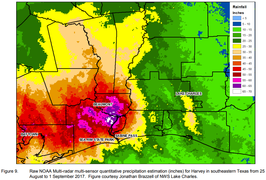
However, there are challenges with accurately measuring historic rainfall during a tropical cyclone. First, many rain gauges have a cylinder that can handle 11-12 inches of rain before having to be emptied, which could be challenging in tropical cyclone or flash flood conditions. Second, gauges are susceptible to wind undercatch, which could reduce their measured totals. In the Hurricane Harvey report, the NHC featured the MRMS radar-derived quantitative precipitation estimation (QPE) as another means of determining the potential maximum rainfall, which estimated 65-70 inches (see image below). These estimated values were outside of any gauge reports.
While Hurricane Harvey showed the utility of MRMS QPE during this historic event, NSSL scientists are continuing work on improving the QPE during tropical cyclone events, including new techniques for handing efficient tropical precipitation and for gauge wind undercatch.